A strong spring storm is heading into the Midwest Tuesday and will bring a wide range of conditions to the area Tuesday through Thursday.
Ahead of the storm, it will be very mild Tuesday with temperatures rising into the upper 50s this afternoon.
As the storm moves closer, colder air will move in Tuesday night, and showers will develop. Rain showers and possible thunderstorms will then continue through the day on Wednesday with much cooler temperatures topping out near 40. Some snow is possible well north of Madison during the day.
The current track of the storm would have it passing through northern Illinois into lower Michigan. This would keep much of southern Wisconsin in warmer air into Wednesday night, then as colder air moves in, rain will change to sleet and freezing rain, then eventually to snow. Snow will taper to flurries before ending on Thursday.
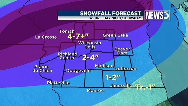
With this track, the highest snowfall amounts will be in central and northern Wisconsin, and totals will fall as you move to the southeast. If the current track holds, we can expect 4-7 inches of snow northwest of Wisconsin Dells, 2-4 inches of snow between Wisconsin Dells and Madison and 1-2 inches of snow southeast of Madison.
There is still time for the track to shift before the storm reaches us, but the general trend with this storm, as with others this winter, has been to move north with time.
Milder air will return quickly on Friday and over the weekend, so any snow we receive will likely melt quickly.


